A national level collaborative Indian Mapping Event


Let us Map India Together!

IITB-ISRO-AICTE Mapathon


Submission
: 14 Dec. 2020 - 31 Dec. 2020
Results
: First Week Of Feb. 2021


registration-map

About Mapathon

The data collected from Indian Space Research Organisation (ISRO) platforms have tremendous potential in mapping India’s resources, agriculture, climate and disaster management, rural and urban planning and in identifying pathways for future development. Such maps can be created using free open source platforms (such as QGIS). Let us join together to create such maps through the Mapathon and end to end innovative solutions through the Hackathon.

What is Mapathon?

Mapathon is map making competition for a specific problem statement. This event, organised jointly by IIT Bombay, AICTE and ISRO, will invite all Indians - to produce maps using Indian remote sensing data. The primary objective is to understand the potential of Indian remote sensing data and make maps for Indian regions using free open source mapping software (QGIS). The participants will collectively work in a crowd sourcing method for jointly producing thematic maps of India using Indian remote sensing data.

Eligibility to participate

All Indian Nationals


Team size and Composition

You can participate as an individual or as a team (max. 4 members). Ideally, a team should have people with basic mapping expertise.


process_flow

Benefits

  • Build Capacity in the Country in Space Applications towards making India an AatmaNirbharBharat & Global GIS hub
  • Enabler Platform for Collaborative Problem Solving

Problem Statements

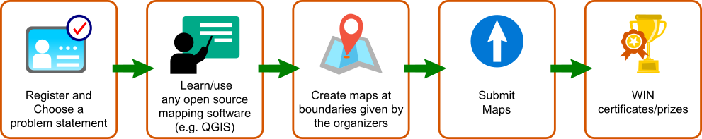
A team can choose one of the problem statements given below or select a topic of their choice

  1. Mapping of natural resources / man-made features.
  2. Change Detection based on AWIFS or LISS III Datasets.
  3. LULC Change with hotspots using LULC maps from Bhuvan.
  4. Flood Maps.
  5. State-wise Health Care Indicators Maps.
  6. Locust infestation / Stubble burning / Low lying areas / Jhum Cultivation.
  7. Road Network / Drainage Maps.
  8. Land Degradation Maps.
  9. Health infra, population, age group etc. for Vaccination.
  10. Detection of change in Waterbodies / Reservoirs / Wetlands.
  11. Choose your own topic.

Data and Helpful Resources for Mapathon

The maps should be created at National/State/District level boundaries using ISRO data. For ISRO Data you may visit the following links:

  1. https://bhuvan.nrsc.gov.in/
  2. https://vedas.sac.gov.in/
  3. https://www.mosdac.gov.in/
  4. https://airquality.iirs.gov.in/
  5. https://nesdr.gov.in/

ISRO Data downloading and access methods

  1. BHUVAN: https://youtu.be/GjaueiRlEU4
  2. VEDAS: https://youtu.be/Qy1hIu8FNQ8
  3. MOSDAC: https://youtu.be/q33C4PriTL0

For boundary data/materials, you may visit this folder and data.gov.in.

Study area boundaries(link):

  • District
  • State
  • India 

FOSSEE-QGIS tutorials

Endorsement Partners

We are happy to announce our endorsement partners.

Partners and Organisers

Forum and FAQs

Have questions or comments? Check our Forum and FAQs.

Coming Soon... HACKATHON

Project Team

  1. Lead - Prof. Kannan Moudgalya
  2. IITB - Prof. Pennan Chinnasamy and RuDRA
  3. ISRO - Team (geomitra[at]isro[dot]gov[dot]in)

Contact Us

For any queries, contact us at mapathon[at]fossee[dot]in